Planning and Zoning 101
The information below is intended to help residents better understand zoning and land development in Brentwood and some of the commonly used terms. A PDF copy of the information is available HERE(PDF, 828KB) .
ZONING DISTRICTS
All land within Brentwood is classified in one of fourteen zoning districts that determine what the land can be used for and lot sizes.
RESIDENTIAL
AR – Agricultural Residential – Provides for larger estate type lots with a minimum size of three acres and general agricultural uses. The property along the historic Old Smyrna Road corridor is an example of AR zoned property.
AR-IP - Agriculture Residential Estate - Innovative Project - A new zoning approved in November 2021 for property owners along Old Smyrna Road to help preserve the scenic and historic qualities of one of the oldest stretches of Brentwood. The AR-IP district provides for a setback of 100’ in addition to a 50’ landscaped buffer. The front yard setback is 100’ and side yard setbacks are at 30’.
R-1 – Large Lot Residential - Provides for large residential lots characterized as having a minimum size of two acres with detached single-family dwellings
R-2 – Suburban Residential - Provides for low density residential development characterized by traditional suburban neighborhoods consisting of detached single-family residences on a minimum lot size of one acre. Example subdivisions include Brenthaven, Meadowlake, River Oaks, and Indian Point.
OSRD – Open Space Residential Development - Provides greater flexibility for creative design of detached single-family residential subdivisions so as to preserve significant natural or manmade features and resources, to minimize disturbance of floodplains and steep hillside areas, to encourage preservation of open space along arterial streets and on other highly visible tracts in the city, and/or to allow for recreational opportunities by incorporating open space into the subdivision. Although individual lot sizes may be less than one acre, the maximum density in an OSRD subdivision shall be no greater than one residential dwelling unit per acre of buildable area. Any reduction in individual lots below one acre shall be permitted only if the land thus saved is designated as open space. Example subdivisions include McGavock Farms, Chenoweth, Raintree Forest, Annandale, and Taramore
OSRD-IP -- Open Space Residential Development – Innovative Project - Allows for innovative residential development that is consistent with the purposes of the OSRD zoning district. The special technical and development standards of the OSRD—IP overlay district are designed to encourage more significant land preservation. In addition, the OSRD—IP standards are intended to encourage a wider range of creative housing options for the community that are consistent with the city's fundamental density standard of one dwelling unit per acre. Example subdivisions include Berkley Walk, Owl Creek, and portions of the Windstone and Taramore subdivisions.
NOTE: The OSRD and OSRD-IP, unlike other zoning districts, require concurrent submittal of a proposed development plan when applying to rezone property to those districts. Said plan is binding and becomes the basis for the subsequent plat of the property.


COMMERCIAL
C-1 – Commercial Office – Office and Service Institution uses are permitted within the district. Permitted uses include General Offices, Medical Offices, and Financial Institutions. C-1 serves as a transitional district between Residential and more intense Commercial uses. The maximum building coverage -- 30%, maximum impervious – 80%, minimum green space – 20% of lot area. Parking Ratio – 1 space / 300 square feet of gross building area. For permitted service institution uses, no more than 70 percent of the lot shall be impervious, 30% green space. Examples include most of Maryland Farms and Overlook Park.
C-2 – Commercial Retail – Office, Retail and certain Service Institutional uses are permitted. Refer to Table 2 for more information. The maximum building coverage -- 30%, maximum impervious – 80%, minimum green space – 20% of lot area. Parking Ratio – 1 space / 300 square feet of gross building area. For permitted service institution uses, no more than 70 percent of the lot shall be impervious, 30% green space. Examples include CityPark Brentwood, Hill Center Brentwood, Cool Springs Festival
C-3 – Commercial Service Warehouse -- Provides suitable locations for wholesale services, warehousing and industrial uses that pose no environmental or public health and safety risk. In addition, the district standards permit general office, retail uses, and certain service institution uses. Examples include Mallory Park and General George Patton Drive areas.
C-4 – Commercial Town Center – Permits a variety of uses, including retail, professional office, service-oriented business, residential, and/or combinations of uses. Encourages a more compact arrangement and pedestrian-oriented approach for development as compared to other commercial districts. The C-4 commercial town center district was designed to facilitate redevelopment of the original northern commercial areas of the city that were substantially developed prior to 1985.

SERVICE INSTITUTION
SI-1 – Service Institution (Religious) -- Provides suitable areas for the expression of religion without creating objectionable or undesirable influences on nearby residential districts. Located between commercial and residential districts and on other tracts adjacent to arterial streets where residential development is not appropriate or feasible.
SI-2 – Service Institution (Educational) - Provides suitable areas for educational and religious purposes and their associated uses without creating undesirable or objectionable influences on nearby residential districts. Located between commercial and residential districts and on other suitable tracts located adjacent to arterial streets where residential development is not appropriate or feasible.
SI-3 – Service Institution (Cultural, Recreational and Government) - Provides suitable areas for open space and recreational uses, cultural and philanthropic uses, educational and religious purposes, local government services, and their associated uses without creating undesirable or objectionable influences on nearby residential districts. Located between commercial and residential districts and on other suitable tracts located adjacent to arterial streets where residential development is not appropriate or feasible.
SI-4 – Service Institution (Retirement/Assisted Care) - Provides for comprehensive group living retirement facilities and individual retirement housing units which address the special needs of residents ages 55 years and older without creating objectionable or undesirable influences on nearby single-family residential districts. Located adjacent to arterial streets with transportation services provided by the development to essential commercial, public, institutional, religious and medical services. Such districts are characterized by mandatory requirements for common operations, support and maintenance services for the residents and the prohibition of fee ownership and transfer of individual dwelling units and lots to the residents in the development.
As shown in the pie chart below, the vast majority of land in Brentwood is zoned for residential use.
DEVELOPMENT TERMINOLOGY
Accessory Structure – A detached subordinate structure, whose use is incidental to the principle structure and located on the same lot. Size and placement standards vary by zoning district. – Ex: sheds, carports, garages.
Acre – A land area of 43,560 square feet.
“One Acre Density” – Brentwood’s residential development standards are based on the concept of a minimum “one acre density”. This means that there is one acre of land allocated with each home. In some zoning districts, this means that each house sits on a lot that is at least one acre in size. In the OSRD zoning districts, this means that homes may be on lots that are less than one acre in size, but there is preserved open space within the subdivision that balances out the smaller lot sizes to still equate to a minimum of one acre of land per house. For example, in an OSRD zoned subdivision, there could be 100 homes on 100 lots that are ½ acre each. This would mean there are 100 homes on 50 acres. However, there must be 50 acres of preserved open space within the subdivision such that the overall subdivision is 100 acres in size and there are 100 homes – maintaining the overall one acre density standard.
Addition – An increase in the gross floor area of a structure.
Alley -- A public or private right-of-way primarily designed to serve as secondary access to the side or rear of those properties whose principal frontage is on some other street.
Arterial Street – A major street carrying a large volume of through traffic in an area. Ex: Maryland Way, Franklin Road, Concord Road, Wilson Pike.
Buffer – A strip of land, including trees, shrubs and sometimes berming installed for screening purposes between one land use and another. Buffer requirements vary by zoning district.
Building Envelope, Buildable Area – The area formed by the front, side and rear building setbacks of a lot in which the principal buildings or other structures must be located. All zoning districts have varying setbacks.
Building Height – The vertical distance of a structure measured from the lowest ground level to the highest point of the roof. Maximum height of a residence is 52 feet. Maximum height of a commercial building is 60 feet depending on zoning district. See the technical standards table above for more specific detail on building height restrictions.
Covenants, Conditions, and Restrictions (CC&R) – Rules enforced by a Homeowners Association (HOA) which usually apply to both the property owner and the home. Also called Restrictive Covenants. These rules are voluntarily agreed to by everyone who buys a home in the subdivision and are generally over and above any City codes or regulations. CC&R's are not enforced by the City.
Caliper Inches – The diameter of a tree trunk for trees taken six inches above the ground for trees up to and including four-inch caliper size and twelve inches above the ground for larger sizes.
Collector Street – A street carrying traffic from local streets to arterial streets. Ex: Charity Drive, McGavock Road, Virginia Way.
Density -- The overall residential density in Brentwood is one dwelling unit per acre. This does not mean that all lots are required to have one acre in area, but a combination of lot area and open space within each residential project to equal the required density. Any reduction in individual lots below one acre shall be permitted only if the land saved is designated as open space in accordance with the Municipal Code.
Deciduous Tree -- Trees or shrubs that lose their leaves seasonally. Ex: Maples, Oaks.
Easement -- Authorization for another to use the owner's property for a specified purpose. Easements are generally created on a lot at the time the lot is platted. Common easements on most residential lots include public utility easements (i.e. water, gas, electric, etc.) and drainage easements.
Evergreen Tree – A plant species with foliage the remains green year-round. Ex. White Pine, Magnolia.
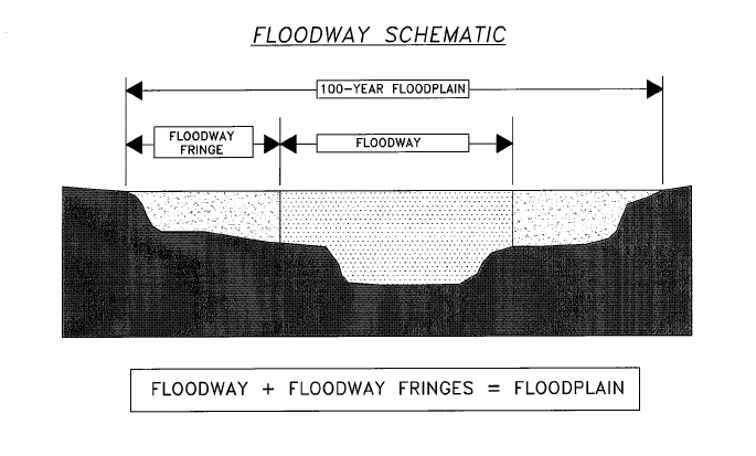
Floodway – The channel of a river or watercourse and the adjacent land area that must remain undeveloped due to the fact it is subject to routine flooding.
Floodway Fringe – The area outside of the designated floodway that is still subject to flooding during extraordinary rain events. Development can occur in the Floodway Fringe via a process known as compensating cut and fill. This means that any material added to a site within the Floodway Fringe must be offset by an equivalent amount of material being removed such that the net effect is no increase in the overall flood elevation level.
Green Space – Generally used to describe the required areas within a commercial or Service Institution project that are left undisturbed, landscaped or grassed. Includes median and parking lot islands. Sometimes incorrectly referred to as open space.
Hillside Protection Overlay -- An overlay zoning district established to meet the challenges of development in the higher elevation areas of the city. The district shall include all areas with an elevation of 850 feet or greater. Requires larger lot sizes (minimum three acres) and restricts the amount of land disturbance and tree cutting on a lot.
Homeowners Association (HOA) – The governing body of a subdivision that sets rules and regulations for a community. HOA’s may require dues payments from all property owners to pay for the cost of maintenance on commonly owned property and improvements (i.e. playgrounds, pools, tennis courts, etc.). Participation in an HOA may be mandatory for all property owners and the rules established by an HOA are in addition to any City codes and regulations.
Level of Service (LOS) – A scale that measures the amount of traffic a segment of roadway or intersection can accommodate. Measured A to F.
Local Street – A street designed to carry residential traffic between collector and other streets, rather than move large volumes of traffic. They are the most common roads. Ex: Interior streets within a subdivision.
Major Thoroughfare Plan - The street map adopted by the City, pursuant to law, showing the configuration and classification of existing and proposed streets, and highways.
Open Space – Areas generally within residential subdivisions designated as permanent preservation areas. Includes stormwater detention ponds. Sometimes incorrectly referred to as “green space.”
OSRD Development Plan – A plan showing the layout of a subdivision, zoned OSRD. The approved development plan shall be included as an exhibit to the rezoning ordinance and shall serve as the basis for design and layout of the subdivision plat.
Plat – A map, prepared by a surveyor representing a tract of land, showing the boundaries and location of individual properties and streets and recorded in the County Register’s office. Also referred to as a Subdivision Plat or Final Plat.
Preliminary Plan -- A generalized plan developed to identify the location and general relationship between sections, in a phased development, land uses, improvements, structures, circulation systems, landscaping and design elements.
PUDE – Public Utility and Drainage Easement. Usually placed along lot lines and street Right-of-way for the purpose of installing utilities.
Right-of-Way -- A strip of land acquired by reservation, dedication or condemnation and intended to be occupied by a public road and other public utilities, (Also referred to as Street Right-of-Way width.)
Roadway or “Functional” Classification –The class, or group, of roads that the road belongs to. There are three main functional classes as defined by the Federal Highway Administration. Includes arterial, collector, and local.
Roundabout -- A circular intersection with a raised island that is usually landscaped and located at the intersection of two street legs used to reduce traffic speeds and accidents without diverting traffic onto adjacent residential streets.
Subdivision – A tract of land divided into two or more parcels.
Setback – Also called “Yard” – The distance that a building or structure is set back from another feature, such as roads, streams or rivers, and property lines. Also see “Building Envelope.”
Traffic Calming -- Engineering and other measures put in place on roads for the intention of slowing down or reducing motor-vehicle traffic and thereby improving the living conditions for residents living along the road as well as to improve safety for pedestrians and cyclists. Ex: roundabouts, speed humps.
Traffic Impact Study (TIS) – A study prepared by a licensed traffic engineer that analyzes the impact on surrounding roads from the increased traffic expected to be generated by a new development proposal. The results of the TIS are used to determine what road improvements, if any, should be required of the developer.